- The diverse plant life and dramatic hills of Brookfield are due to the Niagara Escarpment.
- An escarpment is a long steep slope that forms as a result of erosion or fault lines. This land form separates two areas of land with varying heights.
- An escarpment is a long steep slope that forms as a result of erosion or fault lines. This land form separates two areas of land with varying heights.
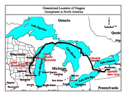
- The escarpment is nearly 1,000 miles-long!
- It runs northeast alongside Lake Winnebago.
- In addition, the escarpment forms most of the Door County Peninsula and continues northeast through Canada and into upstate New York.
- The escarpment is the leading reason why the Great Lakes exist.
- The escarpment is NOT a result of glaciation.
- Although, the glaciers helped expose it.
- The massive land form influences weather patterns.
- Because of this, the escarpment creates an unique environment featuring numerous plant and wildlife species not found anywhere else in the world.
- The escarpment's resources have been used since the 1800’s by french fur traders.
- One of these resources is limestone, which helped to grow urban Wisconsin.
- Limestone from the escarpment is used in cream city brick (Milwaukee’s famous brick).
- Within 2 miles of each side of the cliff, there are about 500 historical sites and structures.
- Most of the land around the escarpment is protected.
- One of the protected areas, High Cliff State Park, is located in the northeast shore of Lake Winnebago.
- It is a 1,187-acre park with 125-acre state natural area.
- In Menomonee Falls, Lime Kiln park surrounds falls of the Menominee river and historic lime kilns/lime quarry.
- In Menomonee Falls, there is a small gorge of Escarpment landscape with 5-10 foot bluffs on either side.
- The southwest side of the Miller Park stadium along VA Center land is one example of how the escarpment affected the land.